Townsend Bluff Inverloch, Circuit Day Hike
- Josh Welch

- Sep 18, 2021
- 3 min read
Updated: Apr 2, 2022
This day hike is a fantastic morning or afternoon hike that sits right at the end of Inverloch which is one of the many beautiful coastal towns down the South Gippsland Coast. Being far closer to Melbourne than Wilson's prom, it is much more accessible to those in the city. This hike offers great views over Andersons Inlet while remaining relatively easy and not too long allowing you to complete it within a morning and get some lunch after in the centre of town. Being around 3.5 KM it may just be the perfect hike to add to your weekend down the Bass Coast or onto Wilson's Promontory.

Packing:
Packing for day hikes is relatively easy but if you are new to hiking or want a little bit of a refresh on what to bring then you can visit our article that covers all called the ‘Day Hike Packing Guide’ Right Here.


Getting there:
Making your way to this hike is very easy, simply input Inverloch into your satnav system and follow it's directions until you reach the town where you will need to find ‘The Esplanade Road’ which follows the inlet. Once you have found the Esplanade you will need to drive towards the Big Four Holiday park down the close end of the road until you reach the Angling Club carpark which will be the starting point of the hike.


The Hike:
From the starting point of the Angling Club Carpark, take a walk through the path next to the exit onto the beach until it emerges onto the shores of the inlet. Follow this beach for about 700 metres until you reach the turn off into another carpark that sits right at the end of the Esplanade Road. You will find a small gate and past this you will follow the track for about 300 metres until you reach the boardwalk followed by the footbridge which crosses Screw Creek. Shortly after the footbridge and after passing the fishing turnoff you will find a split in the path which leaves it open to you to decide which direction to do the loop in, the best suggestion is to take the path on the right where a few hundred metres later you will find a lookout with a bench that looks out onto the inlet towards the town jetty. Further down the path you can find another lookout with a bench that gives a glimpse of the Inlet from a different angle and looks out onto the far side of the inlet and away from the town, this outlook is by far the best on this trail and defiantly worth the walk.


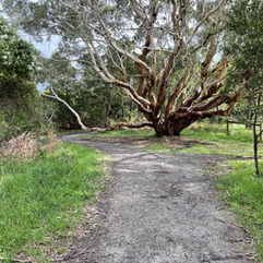
Past this lookout are many she oak trees which when hiking on a gusty day can make howling noises which give off an eerie but yet beautiful sound that makes you feel as if you are in the heart of a uninhabited forest. Walking this path for a few hundred metres further and past some beautiful trees you will find split in the path that you were previously at. To finish the hike you will simply need to follow the same route as the one that first took you to the loop by first crossing the footbridge, walking the boardwalk and following the path until you once again reach the beach. From here you will need to tread back along the same beach as at the start of the hike until you reach the angling club carpark where the walk began.


This trail provides you with a short but yet fun walk that sits close to town and is easy to access for both locals and visitors. This walk can be part of a great day out and after your adventure you should defiantly think about taking a trip into town to try some of the local cafes and coffee shops. This track is relatively lightly trafficked but can have higher traffic numbers when the sun is out and locals come by to enjoy the beautiful outlook over the inlet for a morning walk.
Map:
Helpful Details:
Where: Townsend Bluff Circuit, Inverloch
Distance: 3.5 KM (loop)
Packing: Day Hike Packing Guide
Travel Time: 2 Hours (from Melbourne CBD)
Starting/Finishing Point: Inverloch Angling Club Car park
Duration: One Hour
Difficulty: Easy – Light
Written by Josh Welch


Comments