Bass Coast Rail Trail, Wonthaggi to Anderson Day hike
- Josh Welch

- Oct 16, 2021
- 4 min read
Updated: Apr 2, 2022
Are you looking for a little bit of a challenge while still remaining on a well maintained and well-marked track? Well then the Bass Coast Rail Trail may just be the right hike for you to have a crack at in the near future, with a easy to follow, lightly trafficked and fun trail that offers you with views of the surf beach at Kilcunda and a trip through the back country of South Gippsland. The hike itself is around 16.8 KM’s long making it a great day of hiking to take a break from your daily life and to get out into nature.

Packing:
Packing for day hikes is typically simple and should include a first-aid kit, water bottle, lunch, snack (especially for longer hikes) and navigational equipment such as a map or GPS. For more information on packing for a day hike visit our article that covers everything you need to know called the ‘Day hike packing guide’ right here.


Getting there (and back):
Getting to the start of this hike is as simple as inputting the Wonthaggi Visitor Information Centre into you navigation system and driving there, the centre has a carpark where you can park your car and get ready to set off on the hike from.
To get back from the end of the hike you can either arrange for someone to pick you up from Railway Road or take the V-Line bus back which will drop you off next to the Woolworths meaning a short five minute walk back to the visitor centre to get to the car and get some. Before setting off make sure to check travel times for the busses, it would be advised to get a hard copy of these times to keep with you as sometimes digital technology can fail and it is something you want to have on hand for exactly when you need it.


The Hike:
As said before, the hike starts at the Wonthaggi Visitors Centre across the road from the Harvey Norman, from here you can find the trail that will lead you straight out of town and into nature in-between the Aldi and the Harvey Norman. This trail is very easy to follow and is well marked and pathed allowing you to easily follow it as you hike and leaving very little work for navigation which can be a blessing or a curse depending on what kind of hiker you are. Shortly after you leave the town you will find the many wind turbines of South Gippsland on the left of the trail which is a great sight to stop and admire as you only quite understand how big they are once you see them up close. Shortly after this sight you will find yourself at a small footbridge that is made of wooden planks and quite narrow, after this short bridge you will end up at one of the largest bridges on the trail which from eye is much more sturdy and longer. This bridge is not only longer but in my opinion much nicer as it offers a nice view over the creek below which runs almost the entire span of the bridge.

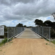


After this bridge you will find yourself stepping out onto a road that runs for a few hundred metres until it meets back up with the regular trail to carry on with the hike and through some of the beautiful Gippsland Countryside. Along the rest of the trail you will find yourself crossing several more less consequential bridges in-between long stretches of trail and the occasional paddock crossing that connects the adjoining paddocks on either side of the trail. After passing some minor and major roads you will find yourself climbing a small hit which once summited will provide you with fantastic views over the surf beach and rocky, rough coastline that sits below Kilcunda. Walking a kilometre further you will meet the most iconic bridge on the trail which many years ago, when this trail was once a railway, serviced trains and took them over another large creek that sits below the bridge. Though the bridge has had some refurbishments, the base of it remains the same as what trains used to travel over and is a great place to take a few photos.


Past this bridge you will find the Oceanview carpark that makes for a fantastic place to stop and have some lunch, there are many picnic tables that you can sit on to take a break and crack out some food which makes organising yourself a lot easier. If you didn't bring lunch with you or
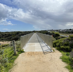
would like a warm, cooked lunch, then you can visit either the General store and Café or the Hotel for a good bit of food and even a coffee. After lunch you can join back with the trail where you will be met with a water refill station, perfect for refilling all your water bottles in anticipation for the final part of the hike. Carrying on down the track you will meet a pair of white gates that sit on either side of the main road which you will need to cross to continue, make sure to keep an eye out for cars here as they come in at around 60 kmph. After crossing the road you can see one of the best parts of the trail which is yet another rail bridge but this time instead of crossing it you will walk past it and get to see it amazing size and construction. To finish off this hike you will need to carry on further down the track and up a slight hillside which is a bit steeper than the rest of the trail, once you have reached the top and it starts to flatten out you will only need to walk a few hundred metres more and you will be at the finish line of your hike.
Map:
Helpful Details:
Where: Bass Coast Rail Trail, Wonthaggi to Anderson
Distance: 16.8 KM (one way)
Packing: Day Hike Packing Guide
Travel Time: 1 hour, 45 Minutes (from Melbourne CBD)
Start Point: Wonthaggi Visitors Information Centre
Finish Point: Railway Road Bus Exchange
Duration: 4-5 Hours
Difficulty: Moderate
Written by Josh Welch


Comments